
Pummelled with Rain Again
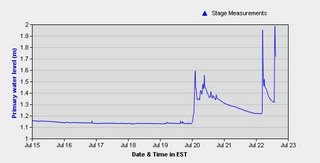
This graph was borrowed from Environment Canada's Real Time Hydrometric Data Website to show you that we got enough rain to raise the water surface of a nearby stream by 0.8 m over 3 days. Today we had two more serious rain events. The website is lots of fun. There are a tonne of streams across the country with data and its actually quite useful in a flood situation. I recall a prof nervously keeping an eye on it the last time that I was in Fredericton around flood season, owing to a low lying cottage downriver.
Yesterday, only a trace amount of rain was recorded at the airport, but here there was a good bit more - in fact after quickly checking all the local meteorological stations I was actually quite surprised by the variation in recorded amounts of rain. The day we go 50 mm - some nearby stations got about 25 while one recorded a total of 69 mm. Weather is cool - what can I say and definately no need to water for a few days.... its pretty soggy here. I picked the stream above because I knew it would be dramatic - this particular stream has a tendancy to flood - although - aside from some agriculture and roads - the stream is fairly unscathed. Nearby 16 Mile Creek on the other hand is highly chanalized through Milton (i.e. - flowing through a not-so-natural- concrete structure) - and doesn't appear to have a station.
Anywho... for those of you up north... there a good chance of northern lights tomorrow night and maybe even tonight - so look up if the clouds will let you.

posted by Jennith at 4:56 PM
![]()
![]()


0 Comments:
Post a Comment
<< Home